Despite early forecasts of a busy Atlantic hurricane season this year has pretty much been a bust...which is good for the beaches! At the moment "Subtropical" storm Melissa is meandering across the middle of the Atlantic on its way northward and poses no threat to the U.S. mainland. (A subtropical storm is one which has characteristics of both tropical and non-tropical storms.)
Given that the hurricane season officially ends Nov. 30th there is little chance of additional threats so Casablanca on 30A is looking like a great place to get away from colder weather up north.
Speaking of that colder weather a succession of fronts has been sweeping south and east across the nation the past couple of weeks. The air masses have been getting colder as the sun retreats further southward in its journey toward the winter solstice next month. One such front cleared through Santa Rosa Beach early yesterday (Monday) leaving behind cooler conditions. Highs today and tomorrow will be "only" in the mid-60s, which is 3-4 degrees cooler than average for this time of year.
By Thursday the thermometer will climb back into the lower 70s ahead of the next cold front which will arrive late Saturday. This boundary will bring the coldest air of the season so far to much of the eastern U.S. and will even drop the high temperatures here to the low 60s (horrors!!). If that sounds more inviting than the temperatures a lot of you will experience to begin Thanksgiving week you need to consider taking a break and head down this way.
A look at the weather features affecting Casablanca on 30A, a Santa Rosa Beach FL vacation property.
Tuesday, November 19, 2013
Tuesday, November 12, 2013
The Arctic Express will roll through quickly
The abnormally cold Arctic front steamrolling across the central and eastern U.S. will dominate the weather story for a few days even here in Santa Rosa Beach. The strong high pressure system behind the cold front is shown in this graphic centered on an axis from north Texas to the Missouri bootheel:
There will be a chance for showers and thunderstorms Friday through Monday but with warmer temperatures and less skin-cracking potential who actually cares?
So c'mon down to Casablanca on 30A and take a break from the early onset of winter weather. No snow here!
The good news is that this airmass will lose much of its punch before arriving here later this afternoon (Tuesday 11/12) so temperatures won't drop as low as areas further north. The coolest day this week is forecast to be tomorrow - Wednesday - with temperatures reaching the upper 50s and a stiff northerly breeze ushering in very dry air, the kind that makes you reach for moisturizing lotion to ward off cracking and peeling skin.
Even better news is that temperatures and moisture content will rebound quickly along highway 30A as the center of the high pressure moves off the East Coast later this week. The clockwise flow around the high will bring southwesterly winds into the picture by the weekend, which will transport both warmth and moisture from the Gulf of Mexico back into the area. Warmer temperatures will result as shown in this forecast map for Sunday (we're inside the white oval):
So c'mon down to Casablanca on 30A and take a break from the early onset of winter weather. No snow here!
Tuesday, November 5, 2013
Nice autumn weather down here
The gales of November...that must be a northern thing since November weather here at Santa Rosa Beach is very pleasant. Today - Tuesday Nov. 5th - for instance there are breezy northeasterly winds and a high temperature in the low 70's. If that sounds a bit better than conditions at your locale you may want to consider heading down this way, especially to Casablanca on 30A.
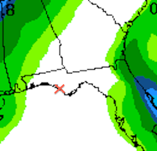
A succession of cold fronts is rolling across the country and will continue to do so under the current pattern known as "zonal flow", which simply means that the jet stream - the upper air current that steers weather systems - is flowing mainly west to east at the moment. Thus there are no deep north/south waves in the flow that could result in stalled storm systems and abnormally cold or wet conditions here at the beach. In fact the seven day precipitation outlook from the Weather Prediction Center (WPC) shows no precipitation accumulation in Santa Rosa Beach (the "x") through next Tuesday, Nov. 12th:
Thus with pleasant autumn temperatures, little or no rain, and a hurricane season that has fizzled why not consider a stay at Casablanca on 30A to soak in some nice weather before your winter settles in? Might as well soak in a few more rays of sunshine and shirtsleeve conditions before hauling out the parkas!!
A succession of cold fronts is rolling across the country and will continue to do so under the current pattern known as "zonal flow", which simply means that the jet stream - the upper air current that steers weather systems - is flowing mainly west to east at the moment. Thus there are no deep north/south waves in the flow that could result in stalled storm systems and abnormally cold or wet conditions here at the beach. In fact the seven day precipitation outlook from the Weather Prediction Center (WPC) shows no precipitation accumulation in Santa Rosa Beach (the "x") through next Tuesday, Nov. 12th:
And as far as temperatures go this map - also from the WPC - shows the forecast high temperatures for the lower 48 states this coming Sunday. Check out the warm temps here versus further north(!):
Subscribe to:
Comments (Atom)


