Tuesday, December 17, 2013

Twas the week before Christmas

Hmmmm...where have I heard that title before? Anyway, the warm weather continues at Santa Rosa Beach while the cold stuff stays locked up further north. Today through Thursday the weather will feature sunshine and temperatures in the mid-60s. How does that sound to those tired of sub-zero weather and gloomy overcast skies?

Even the "bad" weather here isn't hard to take. The extended weekend (Friday-Monday) forecast calls for a 20-40% chance of rain with highs creeping into the low 70s. Every day except Monday the prognostication is for at least partly sunny skies for those who are suffering from SAD (seasonal affective disorder), i.e. lack of sunshine. Oh, and have I mentioned lately that the length of daylight here is longer than up north? Sunrise today was at 6:35 a.m. while sunset won't occur until 4:47 p.m. (all times CST). That adds up to over 10 hours of sunshine even this close to the winter solstice which features the shortest day of the year.

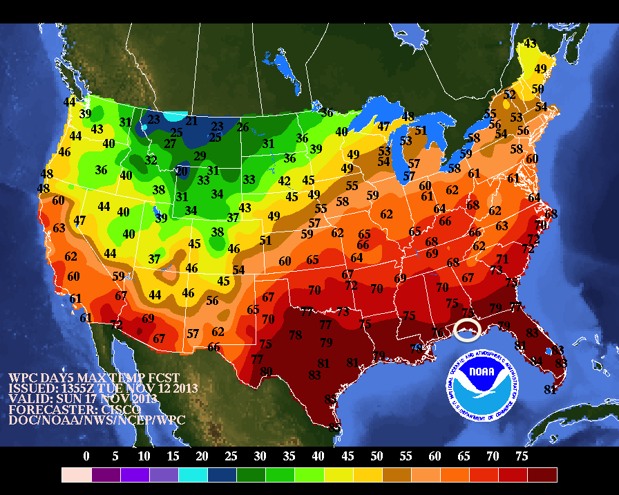
And to make matters even better the jet stream is keeping itself well north of Santa Rosa Beach. This upper air graphic shows how far south over the western U.S. that "river of air" dips this coming weekend:

Even northern Mexico will feel the effects of the dip while the Florida Gulf Coast is warmed by southwesterly flow off the Gulf of Mexico waters.

So if you want/crave/need a break from winter plan a trip to Casablanca on 30A. It's more like spring here!!

Tuesday, December 10, 2013

"Steady Eddie" weather at the beach

Growing tired of the temperature and weather rollercoaster plaguing most of the U.S.? C'mon down to Santa Rosa Beach where the thermometer readings are a lot more pleasant. For example, while the Mid-Atlantic states had ice and snow Sunday (which mostly melted Monday) the same areas are dealing with more snow today. That miserable weather will be followed by several days of much-below normal temperatures as another round of Arctic air plunges southward.

But at Casablanca on 30A? Things are much better than further north! Today's weather is a bit breezy with morning showers and a high in the mid-50s, but tomorrow and the rest of the work week ushers in sunshine and high temperatures in the mid-60s. That kind of temperature regime is a lot easier to deal with than - for instance - what Washington DC is looking at this week, with highs in the low 30s followed by another weekend chance at frozen precipitation.

The rest of December holds promise of more Arctic air plunging southward into the nation's midsection while the Florida panhandle escapes the chill. Here's the latest Climate Prediction Center temperature forecast graphic for the runup to Christmas:
Both the western and southeastern U.S. look to warm up while the "frozen North" stays frozen. Want a break from winter over Christmas? Check out Santa Rosa Beach and Casablanca on 30A!

Tuesday, December 3, 2013

Escaping the brutal Arctic blast

Much of the nation is or soon will be shivering under a powerful blast of Arctic air that is literally coming across the North Pole from Siberia. The cold temperatures are potentially record-setting in many locales for early December and would even feel cold during mid-January. BUT....Santa Rosa Beach will escape the brutal cold!! Check out this high temperature forecast graphic for next Tuesday (12/10) which looks similar to the temperature map for most of this week:

The white oval in the Florida panhandle indicates Santa Rosa Beach.  Check out the temperatures there versus the rest of the nation! The shallow and dense layer of frigid air just won't have enough punch to make it to the Florida Gulf Coast. The nearby clash between the cold and warm air masses will result in a 20-30% chance of rain for Casablanca on 30A from Thursday on but it won't be a total washout.

So with high temperatures in the upper 60's and 70s and lows in the mid-50s it looks like a great time to head south to Santa Rosa Beach to escape December's Arctic plunge. Check it out!

Tuesday, November 19, 2013

One more tropical system for the road

Despite early forecasts of a busy Atlantic hurricane season this year has pretty much been a bust...which is good for the beaches!  At the moment "Subtropical" storm Melissa is meandering across the middle of the Atlantic on its way northward and poses no threat to the U.S. mainland.  (A subtropical storm is one which has characteristics of both tropical and non-tropical storms.)

Given that the hurricane season officially ends Nov. 30th there is little chance of additional threats so Casablanca on 30A is looking like a great place to get away from colder weather up north.

Speaking of that colder weather a succession of fronts has been sweeping south and east across the nation the past couple of weeks.  The air masses have been getting colder as the sun retreats further southward in its journey toward the winter solstice next month.  One such front cleared through Santa Rosa Beach early yesterday (Monday) leaving behind cooler conditions. Highs today and tomorrow will be "only" in the mid-60s, which is 3-4 degrees cooler than average for this time of year.

By Thursday the thermometer will climb back into the lower 70s ahead of the next cold front which will arrive late Saturday.  This boundary will bring the coldest air of the season so far to much of the eastern U.S. and will even drop the high temperatures here to the low 60s (horrors!!).  If that sounds more inviting than the temperatures a lot of you will experience to begin Thanksgiving week you need to consider taking a break and head down this way.

Tuesday, November 12, 2013

The Arctic Express will roll through quickly

The abnormally cold Arctic front steamrolling across the central and eastern U.S. will dominate the weather story for a few days even here in Santa Rosa Beach.  The strong high pressure system behind the cold front is shown in this graphic centered on an axis from north Texas to the Missouri bootheel:

The good news is that this airmass will lose much of its punch before arriving here later this afternoon (Tuesday 11/12) so temperatures won't drop as low as areas further north.  The coolest day this week is forecast to be tomorrow - Wednesday - with temperatures reaching the upper 50s and a stiff northerly breeze ushering in very dry air, the kind that makes you reach for moisturizing lotion to ward off cracking and peeling skin.

Even better news is that temperatures and moisture content will rebound quickly along highway 30A as the center of the high pressure moves off the East Coast later this week. The clockwise flow around the high will bring southwesterly winds into the picture by the weekend, which will transport both warmth and moisture from the Gulf of Mexico back into the area.  Warmer temperatures will result as shown in this forecast map for Sunday (we're inside the white oval):

There will be a chance for showers and thunderstorms Friday through Monday but with warmer temperatures and less skin-cracking potential who actually cares?

So c'mon down to Casablanca on 30A and take a break from the early onset of winter weather.  No snow here!

Tuesday, November 5, 2013

Nice autumn weather down here

The gales of November...that must be a northern thing since November weather here at Santa Rosa Beach is very pleasant.  Today - Tuesday Nov. 5th - for instance there are breezy northeasterly winds and a high temperature in the low 70's.  If that sounds a bit better than conditions at your locale you may want to consider heading down this way, especially to Casablanca on 30A.

A succession of cold fronts is rolling across the country and will continue to do so under the current pattern known as "zonal flow", which simply means that the jet stream - the upper air current that steers weather systems - is flowing mainly west to east at the moment.  Thus there are no deep north/south waves in the flow that could result in stalled storm systems and abnormally cold or wet conditions here at the beach.  In fact the seven day precipitation outlook from the Weather Prediction Center (WPC) shows no precipitation accumulation in Santa Rosa Beach (the "x") through next Tuesday, Nov. 12th:

And as far as temperatures go this map - also from the WPC - shows the forecast high temperatures for the lower 48 states this coming Sunday.  Check out the warm temps here versus further north(!):

Thus with pleasant autumn temperatures, little or no rain, and a hurricane season that has fizzled why not consider a stay at Casablanca on 30A to soak in some nice weather before your winter settles in? Might as well soak in a few more rays of sunshine and shirtsleeve conditions before hauling out the parkas!!

Thursday, October 24, 2013

Sunshine and comfortable temperatures abound

While the northern two-thirds of the nation shivers in abnormally cool late October weather Santa Rosa Beach basks in the sunshine and pleasant weather.  A series of cold fronts blasting across the country opened the door for warm and dry conditions to invade the Gulf Coast with another front due through tomorrow (Friday) morning.  This next frontal passage will be dry and will only drop the temperatures 4-5 degrees from their current highs in the mid-70's to a high Friday and Saturday near the 70 degree mark.

The weather over the weekend and into much of next week will be dominated by high pressure centered over the southeastern U.S. The clockwise circulation around this system will keep light northerly winds in place over the beachfront during the coming weekend.  Those winds will gradually switch to coming out of the northeast and then the east over the first part of next week as the high pressure center itself slides eastward.  The entire effect will be to keep warm temperatures in place along the Gulf Coast similar to those shown in this Weather Prediction Center forecast graphic showing high temperatures for Sunday:
The next chance of rain looks to be associated with another cold frontal passage late next week, probably during the day on Thursday.  Daily high temperatures behind that front also look to be near the 70 degree mark so the weather at Santa Rosa Beach (and of course, Casablanca on 30A) will continue to trump the weather in most other places further north.  C'mon down!

Thursday, October 17, 2013

Pattern change!!

It's officially the latter half of October and a major shift in the U.S. weather pattern is underway.  The cold air that has been building up over Canada and Alaska is sliding southward and will cool things off for much of the eastern half of the nation.  The net effect of such a pattern change at Santa Rosa Beach will be to stall out a frontal system just off the coast and create several days of clouds and showers.  Here is the resulting seven day potential precipitation total for the Florida peninsula, which shows roughly 2.5 inches of rainfall for the beachfront between now and the middle of next week:

Today through Saturday the clouds will reign supreme but Sunday some sun will return.  Then the "big chill" shows up for much of the country as this model forecast for next Thursday afternoon indicates:
The cool blue shading representing the colder Canadian air dives all the way to the Gulf Coast states...but the good news is that it warms up quite a bit before reaching the beaches.  Daily high temperatures will remain in the mid-70's for the majority of the next week altho' I expect next Thursday will be a bit chillier with highs only in the upper 60's.  

After that quick cool blast the weather at Casablanca on 30A will warm back up much quicker than points north and east, so plan to come on down and enjoy the beach!

Thursday, October 10, 2013

An awesome time to be at Santa Rosa Beach

With the Atlantic hurricane season apparently fizzling out while the zombie-like remnants of tropical storm Karen create rainy and overcast misery over the Mid-Atlantic states the weather at Casablanca on 30A remains a great reason for visiting!  There IS no rain in the official NWS forecast through early next week while sunshine abounds.  Temperatures are topping out in the comfortable low to mid-80's every day while morning lows dip "all the way down" to the mid-60's.

Surface high pressure centered near New Orleans is responsible for this delightful weather via its clockwise circulation that ensure the light breezes will head offshore.  This pushes the abundant Gulf moisture away from the beach and provides dry conditions replete with bright blue skies.  In fact the Weather Prediction Center rainfall total map through next Thursday (10/17) shows absolutely no rainfall accumulation for Santa Rosa Beach (red star):


So if you want bright blue skies, abundant sunshine, and warm temperatures make plans to head south to Casablanca on 30A.  It's a great way to extend summertime!

Tuesday, October 1, 2013

Good beach weather until the weekend

The official National Weather Service forecast for this week (and yes, they are still on the job despite the federal gov't shutdown) indicates typical beach weather for Santa Rosa Beach and vicinity.  A 20-40% chance of afternoon showers and thunderstorms and partly to mostly sunny conditions through Friday coupled with high temperatures in the low 80's leaves one to wonder what could be more enjoyable than heading down to the oceanfront every morning.  The weekend, however, could be a different story.

A tropical disturbance with a 50% chance of developing into a tropical cyclone is currently transiting the Caribbean Sea on its way to the western Gulf of Mexico.  Upper air steering currents look to take this disturbance to a point near the Florida panhandle by Friday afternoon as shown in this forecast graphic from the GFS numerical model:
The white circle delineates the tropical system that will join forces with a cold front sweeping eastward across the nation.  The resulting very moist weather system will continue northward across the panhandle and up through the eastern U.S. through early next week, dumping lots of rain as it goes.

The result for Santa Rosa Beach and vicinity will be a fair amount of rain Saturday and Sunday with sunshine returning behind this system on Monday.  Daytime highs will still top out in the low 80's over the weekend even though there could be more clouds than sun.  So if you want a warm place to retreat while autumn temperatures invade the U.S. come on down!

Tuesday, September 24, 2013

Confession is good for the soul

A couple of confessions regarding this Santa Rosa Beach weather blog:

     (1) I have been lax in posting here for a while because we were at Casablanca on 30A for a week and half this month soaking in the sun and overall ambiance!  It was awesome, even more so given the recent upgrades made to the property.
   
     (2) It does rain at the beach now and then...now being one of those times.

The overall culprit for the current rain event at Santa Rosa Beach is a stationary (read "stuck") front that has been hanging around for a few days:
This boundary between dryer and cooler air to the north and warm moist air to the south represents a battleground between the two disparate air masses. The lighter warm moist air is forced upward as it meets the denser cool air, causing the water vapor to condense into clouds and showers along the front itself.  The result is heavy rain and a definite lack of sunshine for the beach areas.

The good news is that the rainfall chances dwindle to nil by Thursday this week as the front is finally pushed southward out over the Gulf of Mexico by a strong East Coast high pressure system that will dominate the weather for a while.  Thus the upcoming weekend will feature plentiful sunshine with highs in the low to mid-80's.  The combination of this expected wonderful weather with an abnormally quiet Atlantic hurricane season means that this weekend and next week would be a perfect time to be at Santa Rosa Beach!

Thursday, August 29, 2013

No hurricanes, just typical beach weather

Let's see...high temperatures in the upper 80's to near 90, anywhere from 20% to 40% chance of afternoon showers/thunderstorms, and partly to mostly sunny skies each day through Wednesday Sept 4th.  Sounds a lot like great beach weather at Santa Rosa Beach!!

The Atlantic hurricane season has yet to produce any tangible threats to Florida panhandle beaches.  There are a couple of tropical waves to watch, one in the middle of the Atlantic and one still yet to emerge off the African coast, but the long range models don't show any tropical systems approaching northwest Florida.

Meanwhile the transition from meteorological summer (Jun 1st - Aug 31st) to autumn (Sep 1st to Nov 30th) is upon us, but as stated above the weather here at Santa Rosa Beach isn't changing much if any.  It will take a while for the seasonal march of cooler air from Canada to reach the Gulf of Mexico so approaching cold fronts will keep washing out north of the panhandle region.  Thus, more great beach weather is on the docket at Casablanca on 30A!!!

Saturday, August 17, 2013

A stretch of not-so-nice beach weather

The southwestern end of a stationary (read "stuck in one place") front is focusing a LOT of rainfall on Santa Rosa Beach now and for the next few days.  The boundary isn't going anywhere any time soon as this Weather Prediction Center forecast graphic for Tuesday morning shows:
The results of this weather setup include a flash flood watch and rip current statement issued by the National Weather Service office in Tallahassee and valid through 7 p.m. Sunday evening.

Total potential rain amounts by next Thursday evening are shown in this colorful graphic:
 The red shading over Santa Rosa Beach - the white star - indicates over three inches of rain, most of which will fall by Tuesday evening.  Yes, it will be wet!

Thus, good beach weather will be hard to come by for a while.  In fact the next day to have anything other than "mostly cloudy" in the forecast is Wednesday when "partly sunny" makes a comeback.  The good news is by that time typical summertime Santa Rosa Beach weather will return with afternoon showers and thunderstorms and highs in the upper 80's.  The only possible fly in the ointment could be the development of a tropical system from a disturbance currently in the southwestern Gulf of Mexico, but the National Hurricane Center only gives 30% odds of that occurring.  (Plus that moisture looks to stay over the western half of the Gulf.)

So, a short term glitch in beach weather but things look like they'll return to normal by midweek.  Casablanca on 30A is calling!

Sunday, August 4, 2013

Hurricane season taking a break for now

If you're concerned about the Atlantic hurricane season affecting your Santa Rosa Beach vacation plans don't be.  Even though seasonal activity usually ramps up from now until its peak in mid-September the action has fallen off quite a bit recently.  Tropical storm Dorian fell apart before it reached the Bahamas and its zombie-like remnants (they just wouldn't go away!!) have merged with a cold front that pushed off the southeastern U.S. coast. 

The rest of the Atlantic convective potential is being squashed by copious quantities of dry air and dust emanating from the Sahara desert as seen in this satellite image that shows water vapor:
The brown area indicates the dry air and associated dust over the Atlantic with no visible convection in this favored area for tropical development.  As a result there is little or no concern from the National Hurricane Center regarding tropical storms that could affect the U.S. mainland for at least the next week.  Satellite water vapor views of the Gulf of Mexico and the Caribbean Sea are equally devoid of convection.

So if you want to enjoy a great August vacation head on down to Santa Rosa Beach and check out Casablanca on 30A.  Along with the typical beach weather of high temperatures in the upper 80's and scattered afternoon thunderstorms the water temperature is in the mid-80's. 

Thursday, July 25, 2013

Goldilocks weather

Highs in the upper 80's, lows in the mid-70's, and chances for showers or thunderstorms almost every afternoon.  That pretty much sums up the outlook for Casablanca on 30A weather over the next several days.  The Weather Prediction Center provides this forecast graphic for the total amount of rain expected over the next five days:
Note that Santa Rosa Beach - the white cross - is in a shaded region indicating a total of 0.75 inches of rain, not a lot for a five day total in a subtropical locale.  Thus the "Goldilocks weather" designation:  not too hot, not too cold, not too much rain...juuuuuuuusttttt right for the beach!

A quick word about Tropical Storm Dorian:  most models indicate this storm will turn northward before reaching the East Coast.  If this trend continues the storm won't affect the Florida panhandle at all.  C'mon down, the water's fine!

Thursday, July 18, 2013

Escaping the heat at Santa Rosa Beach

With high temperatures soaring into the middle and upper 90's over much of the nation the thoughts of cooling seabreezes and a dip in the Gulf of Mexico sounds very appealing.  That, along with a dose of rainfall over the coming weekend, is exactly what Santa Rosa Beach and Casablanca on 30A bring to the table. 

A southerly wind flow at the surface and upper air levels will pump plenty of tropical moisture over the Florida panhandle the next couple of days.  This will enhance the normal afternoon showers and thunderstorms that occur this time of year.  Then, early next week, the air flow swaps around to the west and southwest helping things dry out a bit and provide more sunshine for the beaches.  Temperatures each day over the next week will top out in the upper 80's after morning lows in the upper 70's.

There will be some rainfall most days but nothing like the moisture totals the Panhandle saw last week.  This is a total rainfall forecast graphic from the Weather Prediction Center from this morning through Tuesday morning July 23rd:
The blue shading over most of the Panhandle represents a total of between 0.75 and 1.0 inch of rain spread over this five day period, which is pretty typical for the summer months.

Sound better than the 90's?  C'mon down!

Saturday, July 13, 2013

Rainfall should start tapering off next week

Whew!  The past couple of weeks have featured monster amounts of rainfall over much of the eastern U.S. and Santa Rosa Beach did not escape the deluge.  Check out this precipitation map for the first half of July.  It shows the percentage above normal rainfall:

At the yellow cross - representing Santa Rosa Beach - the area has received over 400% of the normal rainfall for the first half of July.  By any stretch that's a LOT of water.  The culprit is mainly the clockwise circulation around a robust Bermuda High off the East Coast that is pumping tropical moisture northward over the Florida panhandle.  This unmoving high pressure feature is "blocking" the forward progress of weather systems trying to move eastward across the country and the result is a series of "stuck" cold fronts squeezing out heavy rainfall over the same areas day after day.

This heavy rain will continue for the next couple of days as the precipitable water (PWAT) values remain very high.  Coupled with a tropical wave that will cross the Florida panhandle this moisture will provide another two inches of rainfall between now and Tuesday evening.  After that things should settle back down to "normal" Florida summertime weather with a chance of afternoon thunderstorms and highs in the mid to upper 80's.  Of course that means great beach weather!

Sunday, June 30, 2013

Long wave trough will give way to the Bermuda High

Afternoon showers and thunderstorms in and around the Santa Rosa Beach area this time of year are usually due to the sea breeze pushing inland and creating convection. However, the recent persistent rainfall has been from the proximity of a surface front that has been "stuck" just west of the region.  This "stuckness" (if there is such a word) is courtesy of an upper air longwave trough that has taken up residence over the eastern U.S. for the past few days:
I added the blue line which shows the axis of the trough.

 The persistence of this trough is a bit unusual for this time of year but the overall setup has been consistent throughout the past few months, allowing an upper air flow of northerly winds into the Deep South.

Late this week the trough will push back northward and the upper air flow - the jet stream - will resume its normal midsummer west-to-east flow above the U.S. / Canadian border.  This will allow the more typical Bermuda High influence on northwest Florida weather with southerly surface winds pumping in the warmth and moisture from the Gulf of Mexico:

Thus the chances for afternoon showers and thunderstorms will back down a bit as next weekend approaches.  However the Fourth of July holds the promise of Nature's fireworks along with some heavy rains before things settle back down into typical beach weather. 

Saturday, June 22, 2013

Second day of summer and the consistent beach weather continues

Yesterday - Friday 6/21 - was the first day of astronomical summer (different from meteorological summer) and the weather continues to be consistent.  An upper level low pressure is spinning around over Georgia at the moment, producing showers and storms today at Santa Rosa Beach:
Upper level Low (red "L") over Georgia
After that feature moves northward the main influence on beach weather will be the Bermuda High parked off the eastern Atlantic coast of the U.S., pumping air northward from the Gulf of Mexico via southwesterly winds on the backside of this semi-permanent summer high pressure system.  This will continue the trend of afternoon showers and thunderstorms throughout the next seven days with temperatures each day peaking in the mid- to upper 80's and dropping to the mid-70's at night.

Looks like another great beach week coming up!


Tuesday, June 18, 2013

No worries yet for hurricane season and the beach weather is in full swing

The latest National Hurricane Center advisory on Tropical Depression Two shows its track moving westward from the current position to the southern region of Mexico over the next couple of days.
No other tropical systems are on the horizon as of now so Santa Rosa Beach is in the clear for hurricane concerns.

Meanwhile the weather here is being its typical summertime self:  partly to mostly sunny with a chance of afternoon thunderstorms between now and early next week.  The forecast high temperatures range all the way from 85 to 87 degrees (yes, you read that right) with morning lows swinging "wildly" between 75 and 76 degrees.  In other words if you want predictable summer beach weather it's here with nothing in the foreseeable future to change it. 

Sounds like Casablanca on 30A would be a great place to be about now!

Friday, June 14, 2013

It's summertime and the sea breeze is in full swing!

Let's see: 

          Daily highs in the mid-80's.  Check.
          Slight chance of afternoon showers/thunderstorms:  Check.
          Light southerly winds during the day.  Check.

Yep, it's summer at Santa Rosa Beach!  The large scale weather systems - cold fronts, surface low pressure systems, upper level troughs - have moved northward so for the immediate future our weather here will remain pretty much the same, i.e. perfect beach weather.  With partly cloudy skies every day make sure you use plenty of sunscreen as the strong Florida sunshine can quickly redden just about anyone's skin.

So why during the summer is there a chance almost every day for afternoon thunderstorms?  The answer lies in the sea breeze, which forms along the land/water boundary in the absence of other large scale weather features.  This article provides a very good explanation of why the sea breeze forms.
 Once this very localized circulation sets up during the afternoon it provides a lifting mechanism a bit inland from the shoreline which can often push up clouds with enough energy to create thunderstorms.  These popup storms don't usually last long before they rain themselves out and providing perhaps a few lightning bolts as Nature's fireworks.

Just another summertime beach attraction!

Saturday, June 8, 2013

A post-Andrea view

Tropical Storm Andrea is a distant memory for Santa Rosa Beach and the summertime is back this Saturday afternoon with a current temperature in the mid-80's.  There will be a brief hitch in the weather with another disturbance due to drift into the region from the Gulf of Mexico.  This system doesn't appear to have any tropical storm potential but it will usher in clouds and rain Sunday into Monday.

After this weathermaker shuffles on out of the area typical summer conditions return to Santa Rosa Beach for the rest of next week.  With sunshine and temperatures in the mid to upper 80's there will be a chance for afternoon thunderstorms due to the persistent sea breeze that predominates this time of year.  That's the kind of weather that the beach is supposed to have for a good vacation.  C'mon down!

Friday, May 10, 2013

Mothers Day ahead

With Mother's Day weekend upon us a lot of folks are seriously contemplating beach visits as summer approaches.  The weather here at Santa Rosa Beach FL is a great attraction even when a cold front is due through the area as it is this weekend.  After a quick bout with some showers and thunderstorms Saturday as the cold front pushes through the sun will reassert itself for Sunday - Mother's Day - and will stick around for all this coming week.

Temperatures will remain consistent here this next week as they almost always do, with high temperatures reaching the upper 70's and lows near 60 degrees.  Much of the eastern U.S. will shiver a bit under the influence of chilly Canadian air behind the cold front as shown here in this forecast graphic for the pre-dawn hours of Monday morning:
This cold air mass could result in a late season frost as far south as Tennessee and the North Carolina mountains, but note the warmer colors indicated for Santa Rosa Beach at the white star.  No frost here!!   C'mon down!


Monday, May 6, 2013

Springtime in all its glory

The title pretty much sums up the weather this week in Santa Rosa Beach FL.  After a few scattered showers later this afternoon - Monday - with a high of 70 degrees (F) the remainder of the week will feature sunshine and highs in the upper 70's.  The pesky upper level low that has plagued the Midwest with snow and cold air and is now dumping copious amounts of rain on the Mid-Atlantic states is far enough north that it is having very little effect on the weather here in northwest Florida.  In fact here's a current visible satellite view that shows our beautiful clear skies, with the yellow star marking Santa Rosa Beach:

A "cold" front is due through here next weekend but even that will only bring scattered showers and thunderstorms along with continued temperatures in the upper 70's.  Want more spring?  Consider Santa Rosa Beach as a spot for your next getaway, especially the updated rental property at Casablanca on 30A.  You'll be glad you did!

Friday, May 3, 2013

Springtime in Northwest Florida

Those folks shivering in the record-setting May snowfall across the Plains and upper Midwest states should take note that spring has arrived here in Santa Rosa Beach!  Daily high temperatures are climbing into the low 70's and morning lows have been bottoming out in the mid-50's.  Even the heavy rainfall forecast across the southern U.S. courtesy of a cutoff low pressure system will remain mostly to the north of our area this week. 
In fact, after a bout with some showers today (Friday) that could drop a quarter- to a half-inch of moisture to fuel our flower growth the only potential rainfall over the next several days will stem from a "cold" front that will sweep the clouds and dampness out of the area as shown in this forecast graphic for Saturday evening:
The orange star marks our location.
 By next Friday (5/10) the temperatures here will be flirting with the 80 degree mark.  Sound better than snow and overcast skies?  Plan on coming down here soon!!!

Monday, April 29, 2013

A wet but warm pattern

This crazy weather of 2013 has folks over much of the nation scratching their heads and wondering where spring disappeared to.  Continued snowfall in Minneapolis (chance of snow Wednesday night through Friday), seesaw weather in Chicago (80+ degree high temperatures Tuesday and Wednesday followed by 50's Thursday and Friday), and unseasonably cool temperatures along the Atlantic seaboard have all combined to push spring fever to abnormally high levels.

It may be a bit moist here at Santa Rosa Beach this week but it's warm!!  Right now the temperature is 70 degrees and the warmth will continue with high temperatures forecast in the 70's all this week.  In fact check out this temperature forecast graphic for Friday evening:

Note the cool blue and green shades draped across the center of the nation and along the East Coast?  Now check out the warmer yellow shading at the white star location of Santa Rosa Beach.  Even with a daily chance of showers and thunderstorms here it beats shivering up north!!